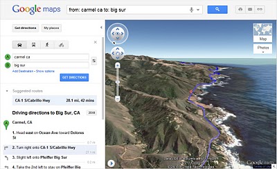
 On Sunday Google’s LatLong Blog announced a 3D “helicopter view” feature for Google Maps. This view provides Google Maps users the option of having an aerial view of their chosen route.
Google Maps engineer Paul Yang described this 3D route preview on Google’s LatLong Blog:
“Getting directions is one of the most popular features on Google Maps, whether it be for driving, walking, biking or transit. Today, we are launching a new feature that allows you to bring your upcoming trip to life, by allowing you to preview your route in 3D.”
To try out this new feature, simply go to Google Maps and put in the starting point and desired destination for your route and select your transportation mode (car, public transit, bike, or walking). Next, click the “3D” play button in order to switch to Earth view. Once in 3D preview mode, you’ll fly along an animated path, viewing the suggested route as if you were in a helicopter. You can also pause the flight by clicking either the pause button, which is located in the lower left, or anywhere in the 3D view screen. Pausing the flight enables you to view the area surrounding your route in 3D mode; simply click and drag the map. You can resume the aerial view flight of your route by clicking the play button, which is also located in the lower left of the 3D view.
This new addition to Google Maps is especially exciting for users who prefer to take the most scenic route. With the 3D “helicopter view” option, users can now preview various routes before deciding which one to take. However, some, not all, Google users can currently try out this feature. No such luck for this user, who was hoping for a scenic helicopter tour of Maui without shelling out $400.
Sources Include: [WebProNews and Google LatLong Blog]


![AI Overviews: We Reverse-Engineered Them So You Don't Have To [+ What You Need To Do Next]](https://www.searchenginejournal.com/wp-content/uploads/2025/04/sidebar1x-455.png)