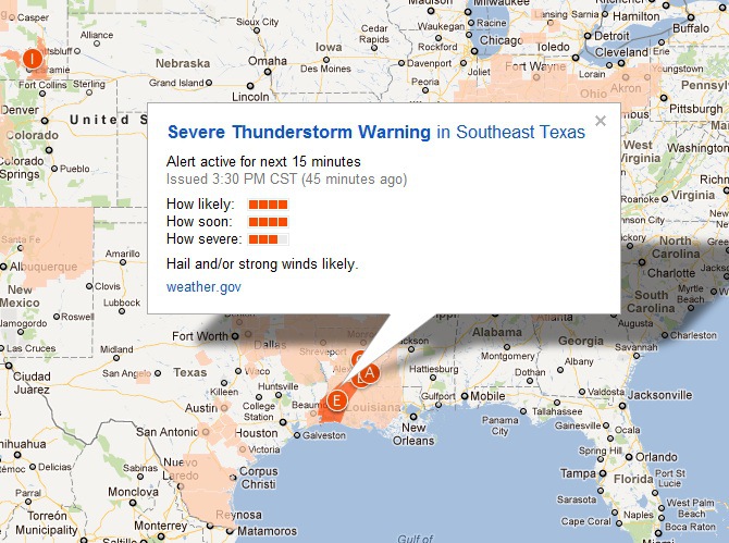
Yesterday, Google launched its new Public Alerts page, which provides emergency information and warnings related to floods, tornadoes, winter storms, earthquakes, and other natural disasters. The information for this innovative project is provided by the US National Oceanic and Atmospheric Administration (NOAA), the National Weather Service, and the US Geological Survey (USGS).
A user that visits the Public Alerts page will see a comprehensive list of all of the current warnings and corresponding “push-pins” on a map. When a user clicks the alphabetically coded push-pin on the interactive map, information regarding the probability the event will happen, the timeframe it will occur within, and the potential severity of the event are all displayed in an easily digestible manner. If a user clicks an alert’s title, they are sent to a webpage containing information regarding the duration of the warning, description of the hazard, other related alerts, and a link to the source information.
Steve Hakusa, a Google public alerts engineer, wrote the following about the new service on the Google Lat Long Blog:
“If a major weather event is headed for your area, you might go online to search for the information you need: What’s happening? Where and when will it strike? How severe will it be? What resources are available to help? The Google Crisis Response team works on providing critical emergency information during crises. Our goal is to surface emergency information through the online tools you use every day, when that information is relevant and useful.”
Hakusa also indicated that the Public Alerts page is a work in progress and encouraged feedback:
“We’re learning as we go and we’re working hard to continuously improve the range and relevance of the content you see, so we’d really like your feedback.”
[Sources Include: Google Lat Long Blog]


![AI Overviews: We Reverse-Engineered Them So You Don't Have To [+ What You Need To Do Next]](https://www.searchenginejournal.com/wp-content/uploads/2025/04/sidebar1x-455.png)